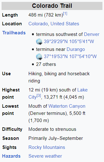
Welcome To The Colorado Trail Trekking Program
Mornings:
The mornings can be the most hectic part of the day. We will usually do a wake-up call around 5:30 am. The time of the wake-up call depends on the
length and difficulty of the hiking day.
At this time, you have four major challenges: eat breakfast, pack your daypack, take down your tent, and pack personal gear for us to load onto the truck. Lunch will be prepared the evening before and stored in a cooler. Please remember to grab your lunch… or you’ll have to beg for scraps from your new friends on the trail! You can avoid some of the morning chaos by doing some ‘evening prep’. Fill your water bottles, pack your daypack, have your next day’s clothes ready, and pack all unneeded items in your duffle.
A hot breakfast is served between 6:00 and 6:30. French toast, hot cereal, pancakes, scrambled eggs or omelet will be some of the offerings during the week. Also available every morning are cold cereals, fresh fruit, yogurt, bagels, cream cheese, instant oatmeal, milk, juice, coffee, teas and hot chocolate.
After breakfast, the crew will be loading up the community camp. If you haven’t already taken your tent down and packed, do it NOW! If your neighbor is running late, consider lending a helping hand. We give extra brownie points to those who help the crew tear down camp and load the trucks.
If mornings seem a bit rushed, it’s because they are! The faster the trucks are loaded and ready to move to the next camp, the faster we can start our hike. Early starts means less likelihood of being caught in late afternoon thunderstorms or arriving in camp after dark! Before the hike can begin, all hikers and crew need to sweep the camp for trash and forgotten items. We want the hike to begin between 7:00 and 7:30 am. The hiking leader for the day will assemble you and give you some final instructions and maybe words of wisdom. The hike cannot begin until everything is loaded and the trucks have their engines running. The reason for this is on one trek the hikers left camp before the trucks were ready to roll and it was discovered that a crewmember had truck keys in his pocket. Another crew member had to RUN up the trail to retrieve the keys!
Hiking:
On your hike, there will be 2 crew members on the trail with you; a ‘leader’ and a ‘sweep’. Each will carry radios to keep in contact with each other and with camp. You are encouraged to hike at the pace that is comfortable for you, but you cannot dawdle. Since we are all of different hiking abilities, we may become quite spread out during the course of the hiking day. We encourage hikers to find at least one ‘buddy’ with whom their hiking style is compatible. In general, the trail is well marked and easy to follow, but the leader will mark any uncertainties on the trail with brightly colored flagging or arrows in the dirt. If at any time you and your buddy become confused or are uncertain that you are on the correct trail, stop and wait for more of the group to catch up to you. Be responsible and aware of your route. If you need to leave the trail for any reason (call of nature, etc.), leave your pack on the trail so you are not overlooked and passed by the sweep guide.
Drink plenty of water! Drink often! Down a quart before you even leave camp in the morning! The importance of hydrating cannot be overstated!!! Do not drink from a stream without a filter or iodine tablets. Eat several snacks in between actual meals. You are burning plenty of calories. Do not wait until you are uncomfortably hungry or thirsty before eating or drinking. Take care of your body before it asks for it and you will feel a lot better.
Hopefully, your hiking shoes are well broken in. Put a blister care product on any known pressure points and stop immediately on the trail to add more if you feel any new ‘hot spots’. It’s easier to prevent blisters than it is to deal with them once they have arrived. Ask for help early before blisters become a serious problem. **See the other printouts for more information on boot and blister care.
Be liberal with sunscreen, and always carry rain gear. In other words, be prepared for any kind of weather--this is Colorado! Your daypack should contain: extra warm clothing (wool or polypropylene are better than cotton), hat, gloves, extra socks, rain pants and jacket, sunscreen, lip balm, camera, lunch, snacks, water, and blister care kit. Don’t bother to bring a cell phone as experience has shown that they do not work well in our mountains. A cap or visor and UV protective sunglasses should help shield your face. Some hikers find a walking stick or hiking poles extremely useful. Finally, enjoy your hike! Don’t feel rushed if others hike faster than you. If you would like to take a rest day, just let your leader know and you can ride with the crew.
When you get into camp, the community tent will be up, the crew will be preparing the evening meal, and there will be snacks or hot soup to refresh you. The shower tent will be up and you will be provided with 2 ½ gallons of warm water to clean up with. We provide a mechanism that pumps warm water through a hose and out of a small plastic showerhead. While you are awaiting your turn to shower, this is the time to set up your tent, relax, eat, and get to know your fellow trekkers.
Dinner/Evening Activities:
Dinner will be served about 6:00 pm. Please try to be on time so no one misses out. If there is more food left after everyone has served himself or herself, then please have seconds. We do not like to have leftovers. We want everyone to be well fed, so please let us know if you have any special needs. Most of the menus have the meat separate to accommodate those who are vegetarians or have special dietary needs.
After breakfast and dinner, the crew sets out a row of dishpans for you to wash your dishes. These dishpans contain: #1: soap, #2: soap, and #3: bleach water rinse. There will be drying racks at the end of row. When you are finished with your dishes, the crew will do their personal dishes and then clean the cooking pots and pans..
Lunch fixings will be spread out on a separate table. These will include: assorted breads, peanut butter, jelly, cookies, fruit, cheese, carrot sticks, chicken or tuna salad, summer sausage and snacks. Fix a yourself a generous lunch with plenty of snacks. Take a few candies to help with your energy level and to moisten your mouth. Remember, you are burning extra calories. If there are any additional foods you would like, let us know and we will try to accommodate you. (We do draw the line at live lobster though.) By the time the dishes are finished and lunch has been fixed, people are starting to head to their tents for a well deserved rest. If you stay up later than most, please respect others’ need for sleep.
Other Camp Details:
- There is a hand washing station available at all times. We strongly encourage its use!
- We have plenty of potable water available for drinking.
Download a PDF of this pageClose